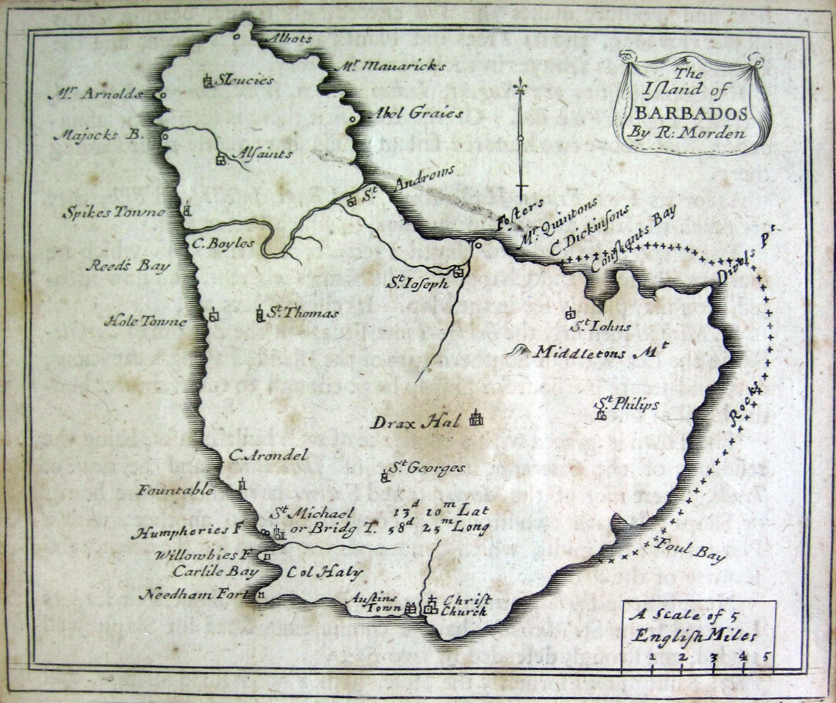
Historic Map of Barbados - Morden 1688
I always find old maps very interesting so was overjoyed to be able to look at this one - a very interesting map of Barbados dating back to 1688 by R. Morden.
A feature of particular interest on the map is the river gully marked through St Andrews that appears to cut through the entire island!.
Also of note is the progression of names to the modern the equivalent. For example, Spikes Towne - Speightstown (refered to in the text as Sprites Town and Little Bristol), Majocks B - Maycocks Bay, Fauntable - Fontabelle and suchlike.
The text gives some short descriptions on the 11 Parishes of Barbados including details on St. Michael - referred to as St. Michaels.


The text reads :-
"Barbado's is the most considerable island, that passes under the name of the Caribe Isles. It is seated in 13. degrees and 30. min. of North Latitude: being not above eight Leagues in length, and five in breadth of an Oval form. It is a potent Colony, and able to arm ten thousand fighting Men, which with the strength that Nature hath bestowed upon it is able to bid defiance to the stoutest Foe.
This Isle is very hot, especially for eight Months, yet no so but labour or travel is sufferable by reason of the cold Breezes of Wind, which rise with the Sun, and blow fresher as the Sun mounteth up. The Air tho hot is moist, which causes all iron tools to rust, but this great heat and moisture makes the Soil exceedingly fertile, bearing Crops all the year long, and it's Trees and Plants are always green, and the Fields and Weeds alwayes in their verdent livery.
It's Commidities are Sugars, Indico, Cotten, Wool, Ginger, Logwood, Fustick, Lignum Vitae &e. Of the four first there is such a great abundance, that above two hundred sail of Ships have yearly their loading there.
As for its Trees, Fruits, Herbs, Roots, Foul, Beast, Insects, and Fish they are much the same as found in Jamaica, to which I refer you
The island is divived into eleven Precincts or Parishes, in which are fourteen Churches and Chappels. The Names whereof, and how situated, you my plainly see in the Map. It's chief places are,
St. Michael, formerly, Bridge-town, situate at the Bottom of Carslile-Bay in the Lee-ward or Southern part of the Island, having a capacious, deep and secure Harbour for Ships, large enough to entertain five hundred Sail at once.
The Town is graced with a bundance of well built houses, being the residence of the Governer, the place of Judicature, and the Scale of Trade, where most of the Merchants and Factors opposite one to another, with a Plat-form in the midst, which commands the Road for the defence and security of the Ships.
Next is little Bristol, formerly Sprights Bay, seated about four leagues Leeward from St. Michaels, hath a commodius Road for Ships, well traded and strongly defended by two Forts.
3. Saint James, formerly the Hole, hath a good road for Ships, and is of a considerable Trade, where is kept the Monthly Courts.
4. Charles Town, on Oyster Bay secured by two strong Forts with a plat-form in the midst.
The inhabitants of this Isle are of three sorts, Masters, Christian Servants, and Negroes. And according to the Calculation not long since made, the two first did amount to fifty thousand, and the Negroes to double the number.
The Masters for the most part live at the height of pleasure, and the Servants at the experation of five years become freemen of the Island, and imploy their times according to their abilities and capacities, and the Negro Slaves are never out of their Bondage, and the Children they get are likewise perpetual Slaves."